North Mississippi Corps Lakes Hunting
While I have hunted many of these places, some I have not. Let this be a starting point for your planning and research.

Sardis Lake (Certain Areas require free permit)
Corps Hunting Regulations 2024-2025 Vicksburg District (.pdf download) covers Sardis Lake, Enid Lake, Grenada Lake and Arkabutla Lake
Corps Hunting Regulations 2020-2021 Vicksburg District (.pdf download)
Corps Hunting Regulations 2018-2019 Vicksburg District (.doc download from Enid Lake website)
According to the Vicksburg District of the Army Corp of Engineers
Sardis hunting areas offer a wide mix of habitat that include forested areas with pine, hardwood, and pine/hardwood mix, open fields and wetlands. These areas offer an abundant source of food and cover for the wildlife that is indicative of this region. Additionally, wildlife food plots are planted and maintained yearly at Sardis Lake. These areas provide nutrition for White-tail deer, Bobwhite quail, Eastern wild turkey, migrating waterfowl species, rabbit, dove, raccoon and squirrel. Some of the planted crops species are sorghum, soybeans, chufa, millet, clover, wheat and corn.

Enid Lake
Corps Hunting Regulations 2024-2025 Vicksburg District (.pdf download) covers Sardis Lake, Enid Lake, Grenada Lake and Arkabutla Lake
Corps Hunting Regulations 2020-2021 Vicksburg District (.pdf download)
Corps Hunting Regulations 2018-2019 Vicksburg District (.doc download from Enid Lake website)
Enid Lake Brochure Map (Link) (Download)
Enid Lake Hunting Map (2012) (Link) (Download)
According to the Vicksburg District of the Army Corp of Engineers
Enid Lake provides excellent hunting opportunities with over 17,000 acres of managed forest lands. Throughout the fall, hunters spend countless hours scouting and hunting the abundance of wildlife that includes deer, squirrel, rabbit, turkey and duck. Through partnerships and volunteer efforts, Enid Lake manages two premier wildlife management areas – Springdale Wildlife Management Area (Deer Hunting Only) and Dean Hill Wildlife Management Area at “Wildcat Brake”. These areas encompass more than 3,700 acres of unique habitat and prime hunting opportunities. Hunters are provided an opportunity to hunt in a sanctuary of old river runs, sloughs, open bottom lands, wetland grasses and a mixture of hardwood and pine stands. Throughout the year Enid Rangers spend numerous hours introducing children to the outdoors and promoting environmental stewardship and wildlife/fisheries ethics. WILDLIFE MANAGEMENT AREAS Springdale Wildlife Management Area - 1,537 Acres, Dean Hill Wildlife Management Area at "Wildcat Brake" - 2,276 Acres

Grenada Lake
Corps Hunting Regulations 2024-2025 Vicksburg District (.pdf download) covers Sardis Lake, Enid Lake, Grenada Lake and Arkabutla Lake
Corps Hunting Regulations 2020-2021 Vicksburg District (.pdf download)
Corps Hunting Regulations 2018-2019 Vicksburg District (.doc download from Enid Lake website)
Grenada Lake Brochure Map (Link)
Grenada Lake Hunting Map (Link)
According to the Vicksburg District of the Army Corp of Engineers
From the hills and hollows to the fields and wetlands, Grenada Lake offers some of the best hunting opportunities in the nation. The Grenada Lake Project encompasses 90,427 acres; with much of this area open for public hunting, offering excellent opportunities for deer, turkey, squirrel, rabbit, and duck hunting.
Each year our Wildlife Biologist and Natural Resource Rangers develop and plant food plots to attract and enhance wildlife. All developed areas, including campgrounds and day-use areas are closed to hunting. With the exception of special hunts (permit hunts), the five management areas noted on the location map and highlighted in yellow are closed to hunting. Grenada Lake is also closed to hunting on the west end of the lake from Perry Creek to Knights Creek.
The Mississippi Department of Wildlife, Fisheries, and Parks establishes and enforces hunting seasons, bag limits, and regulations on U.S. Army Corps of Engineers properties. Please refer to the Mississippi Outdoor Digest or contact the North Region Office for specific questions at (662) 840-5172. Hunters are reminded not to drive nails into trees or permanently affix a stand or blind to any trees.
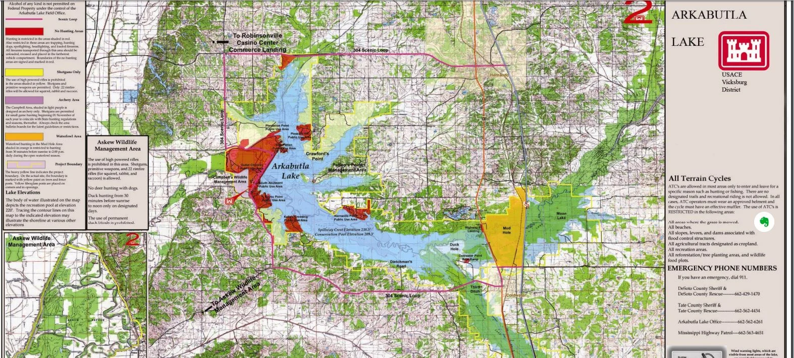
Arkbutla Lake
Corps Hunting Regulations 2024-2025 Vicksburg District (.pdf download) covers Sardis Lake, Enid Lake, Grenada Lake and Arkabutla Lake
Corps Hunting Regulations 2020-2021 Vicksburg District (.pdf download)
Corps Hunting Regulations 2018-2019 Vicksburg District (.doc download from Enid Lake website)
Arkbutla Lake Brochure Map (Link)
Arkbutla Lake Hunting Map (Link)
According to the Vicksburg District of the Army Corp of Engineers
With Arkabutla Lake being located in one of the fastest growing regions in the state of Mississippi as well as being the closest Corps lake to the Memphis metropolitan area, it should be comforting for outdoor enthusiasts to know Arkabutla Lake has over 30,000 acres of land open for public hunting. More than 20 access areas are available to hunters making Arkabutla Lake accessible from almost anywhere. Just a reminder… when hunting on Arkabutla Lake lands, all federal and state hunting regulations apply. In addition to federal and state hunting laws, the Corps of Engineers at Arkabutla Lake has also established specific rules and regulations that apply to certain areas surrounding the lake. These rules and regulations are listed in the lake’s brochure map.