9/8/2020 Enid Lake Fishing Report
Alert
Work continues on the bridge to the dam from I-55, but the road will remain closed until the new bridge is completed. Continue to use marked detours.
Fishing Report
Enid Lake - 9/8/2020 3:04:08 PM
Bass
Largemouth Bass will either be following channels (river, creeks, and ditches) as falling water moves them toward the main lake, or will be on major points, ledges, etc. Any cover (timber, rocks, brush tops, etc.) is a plus. Fish topwaters at dawn, dusk, or at night and crankbaits, bladed jigs, or soft plastics during the day.
Crappie
Best luck has been either trolling or drifting jigs and/or large minnows in mouths of major creek coves and the main lake 6 - 12 ft deep over deeper water. Some trollers report better success fishing longer rods or planer boards that get baits away from the boat. Single pole fish the same baits and depths in standing timber, brush piles, etc. near deeper water (channels, sloughs, etc.). Pulling or pushing crankbaits is also producing. Larger baits will catch more keepers and fewer short crappie. Please replace treble hooks with single hooks and/or pinch down the barbs to reduce damage and increase survival of short fish. Expect some catfish and White Bass along with the crappie.
Bream
Bream have been in similar places as bass. Fish any cover (stumps, brush tops, etc.) with crickets or worms under a bobber 4 - 8 ft deep.
Catfish
Fish in the river and creeks with worms or stinkbaits if there is any rainfall runoff. Otherwise, fish over main lake flats with various natural baits on rod-and-reel, noodles (jugs), or trotlines.
White Bass
Fish shad-imitating jigs or small crankbaits off sandy, main lake points at dawn and dusk; the Wallace Creek cove and the points on either side are usually good. Watch for schooling activity and have one rod rigged with something you can cast a long way. There are no Striped or Hybrid Striped Bass in Enid, just White Bass which have no size or number limits.
Fish Detail
The lake is on fall drawdown. Fish will be following the water, whether it is rising or falling. Fish in or near tributaries, ditches, and other travel routes. Water falling, fish deeper; water rising, fish shallower.
Species
Crappie (combined black and white)
Minimum Length Limit12 inches and under
Species Detail
Limits
Crappie (combined black and white)
15There is a 40 crappie per boat limit for boats with 3 or more anglers.
Limit Detail
Anglers may use no more than 4 poles per person and no more than 2 hooks or lures per pole.
Spillway
Water Body
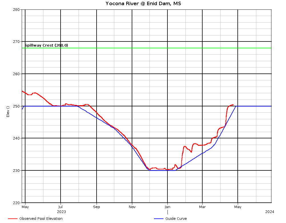
Water level 248.52, falling 0.2 ft/day, 3.1 ft over rule curve Tuesday. Expect rises and drawdowns as the Corps tries to achieve and maintain rule curve. The water level should fall from summer pool (250 ft) August 1 to winter pool (230 ft) by December 1. Emergency spillway level is 268.0. For water level information, call (662)563-4571 or check at http://www.mvk-wc.usace.army.mil/docs/bullet.txt for a table or http://www.mvk-wc.usace.army.mil/plots/enidplot.png for a graph or http://www.mvk-wc.usace.army.mil/resrep.htm for both (click on 24 hour change for picture explanation of gate flow, spillway flow, etc.). Be sure to check the date on the table as it is not always updated daily. Contact the COE office (662) 563-4571 for accessible ramps at current water levels. With the water level just over summer pool, most ramps should be accessible.
Content
Additional Information Mississippi Department of Wildlife, Fisheries, and Parks Fisheries Biologists use various sampling methods to assess the fish populations in the State’s waters. Sampling results for selected water bodies are summarized in Reel Facts Sheets.