3/17/2020 Sardis Lake Fishing Report
Link to 4/3/2019 Sardis Lake Fishing Report
Link to 3/26/2019 Sardis Lake Fishing Report
Link to 3/20/2019 Sardis Lake Fishing Report
Link to 2/19/2019 Sardis Lake Fishing Report
Source MDWFP https://www.mdwfp.com/fishing-boating/fishing-reports/sardis-lake/
Alert
There is an old newspaper article that has been circulating on social media and the internet. There are no changes to crappie regulations on Sardis this year.
The road is repaved and open to Hurricane Landing. Although signs may say road work ahead, etc., the bridges on the road to Clear Creek have been replaced and repaved.
Fishing Report
Sardis Lake - 3/17/2020 3:21:04 PM
SpeciesDetailLargemouth BassLargemouth Bass will be following creeks and ditches into shallower water with the water rising. It is mid/late April until spawning. Look for the clearest water with any cover. Lure choices will depend on water level and temperature trends. Fish faster moving lures shallower if warm and/or rising and slow down and fish deeper if cooler and/or falling.CrappieBest luck has been either trolling or drifting bright colored jigs and/or minnows above Clear Creek in the main lake and creek mouths about 5 - 7 ft deep. There have been some reports catching fish 2 - 4 ft deep (mostly males) in 5 - 6 ft of water in the bushes.BreamNo reports.CatfishPresent conditions are best for catfishing. Fish in the river and creeks or recently flooded flats using various natural baits on rod-and-reel, noodles (jugs), or trotlines.White BassWhite Bass are making their spawning run up tributaries; males usually go first. The river near Hwy 7 is a good spot. Fish jigs or small crankbaits over a sand bottom. There are no Striped or Hybrid Striped Bass in Sardis, just White Bass which have no size or number limits.
Fish will be following the water as it is slowly rising. Fish shallow cover near tributaries, ditches, and other travel routes. Warmer weather mid-week may move crappie shallower, but a cold front is predicted this weekend. Water falling, fish deeper; water rising, fish shallower.
Special Fishing Regulations
Species
SpeciesTypeLength To ReleaseCrappie (combined black and white)Minimum Length Limit12 inches and under
Statewide creel and size limits apply to all other fish species.
Creel Limits (per person, per day)
TypeAmountAdditional InformationCrappie (combined black and white)15There is a 40 crappie per boat limit for boats with 3 or more anglers.
Anglers may use no more than 4 poles per person and no more than 2 hooks or lures per pole.
Spillway
The spillway had two gates open 12.0 ft each, two gates open 2.0 ft each (6280 cfs) Tuesday. Best luck in the spillway and Lower Lake is when some water is being released, but not too much. Right now it is almost too much. Some crappie are being caught trolling in the Lower Lake. For crappie, fish jigs and/or minnows out of any current or right along the rocks or slow troll in the Lower Lake. Catfishing is best on natural bait fished near the bottom. White Bass will be in any current where you can drift a 2 jig rig just off bottom (watch the rocks!) or fish small crankbaits or tailspinner lures. For largemouths, cover in the old river run is the best bet, or fish right on the rocks in the spillway with crankbaits or spinnerbaits. Expect some Spotted (Kentucky) Bass mixed in where there is current.
All fish captured and kept with dip or landing nets, cast nets, boat mounted scoops, wire baskets, minnow seines, and minnow traps in the spillway areas bordered by rip rap must be immediately placed on ice or in a dry container. Game fish caught with these gears must be released. This regulation was enacted to reduce the potential of transferring harmful Asian carps to the reservoir or other waters.
The 12-inch crappie length limit does not apply to the reservoir spillway, but the spillway, including Sardis Lower Lake, has a 15 crappie creel limit.
Water Level
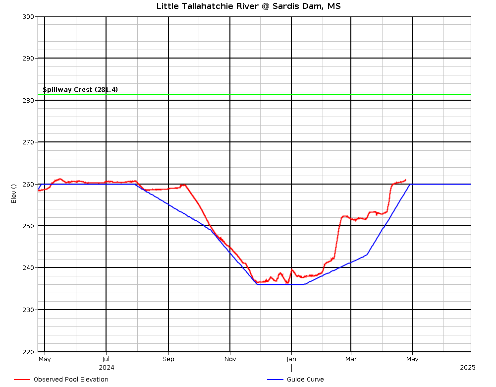
Water level 262.31, rising 0.23ft/day, 18.4 ft over rule curve Tuesday. Expect rapid water level rises and drawdowns as rain events happen and the Corps tries to maintain rule curve. The water should be rising to 241 ft by March 1 and then to 260 ft (summer pool) by May 1. Emergency spillway level is 281.4. For water level information, call (662)563-4531 or check at http://www.mvk-wc.usace.army.mil/bulletin.txt for a table or http://mvk-wc.usace.army.mil/plots/sardplot.png for a graph or http://www.mvk-wc.usace.army.mil/resrep.htm for both. Be sure to check the date on the table as it is not always updated daily.
Contact the COE office (662) 563-4531 for accessible ramps at current water levels.
Additional Information
Mississippi Department of Wildlife, Fisheries, and Parks Fisheries Biologists use various sampling methods to assess the fish populations in the State’s waters. Sampling results for selected water bodies are summarized in Reel Facts Sheets.